KARELIA MAP - A FINNISH RUSSIAN FRONT
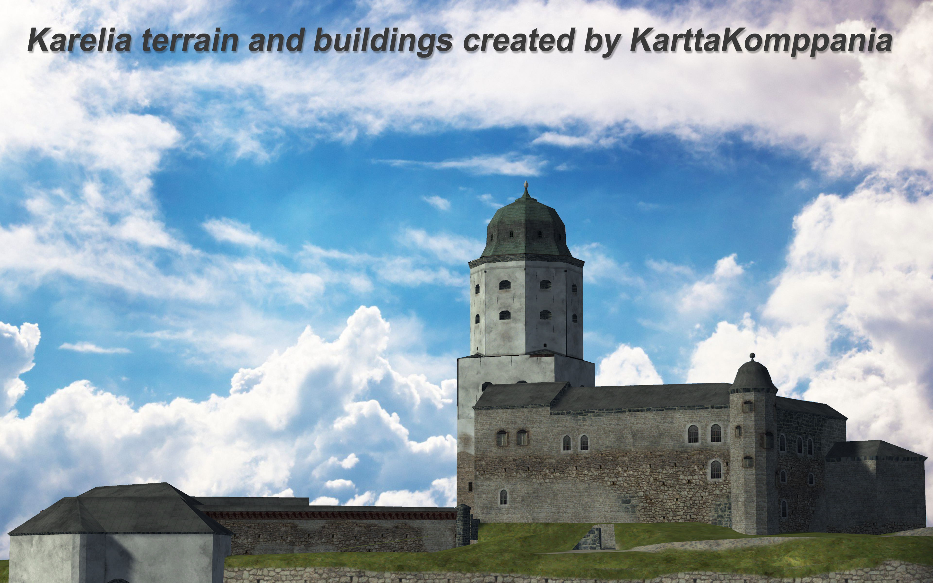
Vyborg Castle modeled and texture by Petri Peltola.
A working group called KarttaKompania has made the Karelian terrain (map) to the well-known international IL-2 Sturmovik Great Battles flight simulator dating back to the Second World War. We are working to have the map finished and ready for publication by the end of 2023. Developers has seen the map files and it has been agreed with it in September 2022 that the map will be published as a map of the IL-2 Sturmovik flight simulator as soon as it is ready.
We have collaborated with the Finnish Air Force Museum and private experts. For example, the most internationally known Finnish aviation historian Carl Fredrik Geust has made available to us his versatile and extensive archive of airports and wartime aerial photographs.
Our intention is that with this game map, Virtual pilots from all over the world will get a lot of interesting military historical information about the Finnish winter and continuation wars and the activities of the Finnish air force with a very accurate historical map dating back to the war years and with historical flight missions.
The map is modeled as the region was at the end of the 1930s before the Winter War during peacetime. In the flight simulator, you can also fly scenic flights with civilian planes in different seasons and see what Karelia, its cities, villages and landscapes were like just before the wars.
First Karelia Map Will Be Completed 2023
The goal of 2023 is to have the central area of the map, the Karelian sthmus and the bottom of the Gulf of Finland, completed and tested by the Virtual Pilots multiplayer server with the gaming house. The flying area of the Karelian Sithmus map is 280km x 210km. Outside of this delimitation, there is fairly ready-made terrain 70 km north, east and south. We will finish that area in 2024 when the first version is ready for publication. After that, the size of the map is about 410km x 410km and the area to be flown is about 350km x 350km.
Most of the historical airports, largest cities, towns, church villages, urban areas and factories are already marked on the navigation map, but it is being updated all the time. By clicking on the map, it opens in another tab with full resolution.
Ground Cover Restoration Work Completed
The Photoshop work on the ground cover has been done with four times the precision where 1 pixel = 2.5 meters. The terrain files currently used by the simulator are reduced to a resolution of 1 pixel = 10 meters. Even with that resolution, the shorelines are already drawn very precisely and almost all rivers 20 meters or wider come into the simulator's landscape.
The basis of everything is water obtained from satellite data to which old Finnish old maps of Karelia (1:20,000) and topographical maps of the Soviet Union from the 1930s (1:25,000 and 1:50,000) have been aligned. The entire terrain is geographically made as correct as possible and synchronized not only with the water data but also with the height data.
The picture above shows a sample of the edited land cover from the Vyborg region. It shows the precision of the editing work done with Photoshop: from the old 1:20,000 maps of Karelia, different types of land covers have been drawn by hand with their own colors on different levels. The land cover files are made into black and white bitmaps, which are then processed and compressed with official IL-2 map tools. They get the final elevation, forest and water files needed by the game engine.
The road and railway network is being completed
The main road and railway network is already completed in the central area of the map. It is made with vector graphics using old road maps, topographical maps and reconnaissance aerial photographs. Roads and railways are placed in the landscape with an accuracy of 10 meters in their historically correct grooves. The road network will be completed in the entire area of the large 410km map during 2023.
The road map of Karelian Isthmus from 1939 shows class I and II roads and also railways.


